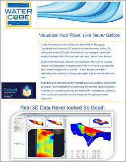
Visualize Your River, Like Never Before!
Cubeit Unlimited provides advanced capabilities for Managing, Comparing and Analyzing 3D spatial river data like never before. By utilizing the power of Cubeit Unlimited you can compare results and analyze changes within the river year over year, season over season.
Cubeit Unlimited helps engineers and scientists who need to visualize velocity and bathymetry throughout the entire river reach to access that data quickly through built in queries. It also assists scientists in calibrating their models by utilizing real spatial data anywhere within the river.
Engineers and scientists need to manage data sets, discover trends and anomalies, and understand the underlying physics that cause variations. In addition to visualizing velocity and bathymetry, temperature variations, water quality and sediment can be visualized throughout the area measured.
Click the image below to download our Cubeit Unlimited data sheet in PDF format: